Boardman/Ottaway Downtown Riverwalk
Latest Update
On January 16, 2025, the DDA Board approved the Schematic Design and Design Development phases for Phase One of the Lower Boardman/Ottaway Riverwalk.
The scope of Phase One includes:
- The J-Smith Walkway
- New pedestrian amenities through the adjacent alley and parking lot
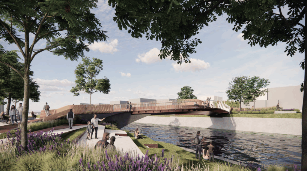
- A new pedestrian bridge connecting to pedestrian improvements on the north side of the river, including the proposed Farmers Market Pavilion
The design reflects years of visioning and community engagement, including the Unified Plan for the Lower Boardman River adopted in 2021 and the conceptual design completed in 2023.
Project Cost and Funding Context
- The estimated construction cost for Phase One is $5,528,221.
- When accounting for contingency and other potential variances, the total estimated project cost is $5,749,350.
Next Steps For Project Advancement
Should the DDA Board elect to move the project forward, the remaining steps include:
- Development of Construction Documents
- Bidding and Award
- Construction
With the Schematic Design complete and a refined cost estimate now established, the DDA Board is better positioned to evaluate how this project fits among other DDA funding priorities for the next two fiscal years – the remaining life of TIF-97.
Riverwalk Design
Project History
The 1.6-mile segment of the Boardman/Ottaway River in Downtown Traverse City
has long served as the center for human activity in the Grand Traverse region – home first to the Anishinbek people and then European settlers who used the river and the surrounding forests to leverage a robust logging industry. As early settlement and industrial development around the river expanded over the 19th century, much of its associated waste went directly into the Boardman River. Over time, the ecology, habitat and overall health of the river was severely impacted. As a result, much of the built environment near and along the river either “turned its back” to the river or were relegated to less than desirable land uses or forgotten spaces.
While the ecology, habitat and overall health of the river is now considerably better, in many places along the river in downtown, the legacy of that early built environment still exists today – retail and commercial buildings face away from the river, surface parking lots and concrete walls line areas along the river, public access is limited, old concrete slabs and infill material protrude from the riverbank.
Despite its prominent role in defining the trajectory of much of Traverse City’s past, the river’s place within the urban fabric of downtown Traverse City today feels disconnected and not well defined.
Over the past twenty years, a number of local, state, federal and tribal stakeholders, have worked together to dramatically restore the upper reaches of the Boardman River, with one of the largest dam-removal and habitat restoration projects in the history of the greater Great Lakes Basin. Work also continues on FishPass, a capstone of the 20-year restoration project, which will ultimately re-connect the river to Lake Michigan and re-establish hydrological and ecological connectivity without allowing the passage of invasive species
Over that same time period, the City of Traverse City and Downtown Development Authority have implemented a series of boardwalks and pedestrian bridges along portions of the river that flow through downtown. While these well-intentioned projects provide additional access to the river, the disjointed network lacks cohesion and fails to properly connect the river corridor with downtown.
Let’s Develop a Plan
In 2018, noting the lack of a comprehensive vision and plan for the Lower Boardman/Ottaway River corridor and facing increasing development pressure along the river, the Downtown Development Authority initiated a planning effort to develop a Unified Plan for the Lower Boardman/Ottaway River. The Unified Plan (which was adopted in 2021 by the DDA, Planning Commission and City Commission) provides the framework and blueprint for significant pedestrian, placemaking and habitat restoration efforts along the river, supporting a long-held desire for downtown to “turn and embrace” the river.
The centerpiece for this transformation is the north and south banks of the river between Union Street and Park Street. The south side of the river lies adjacent to the alley behind the 100 and 200 blocks of Front Street. Both alleys provide “back-of-house” access to the restaurants, retail establishments and other uses along Front Street, which serves as the commercial core of downtown Traverse City. The 100-block alley is lined with dumpsters, utility boxes and an expansive parking lot that rests right up against the concrete retaining wall of the river. The 200-block alley is much narrower, but include many of the same features. The north side of the river has a small riparian vegetative buffer, but is otherwise bordered by expansive parking lots. The north side of the 200-block also has an existing boardwalk that was erected in 2017.
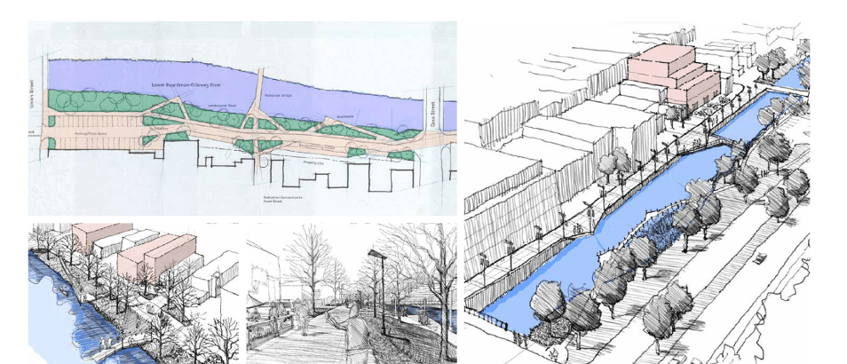
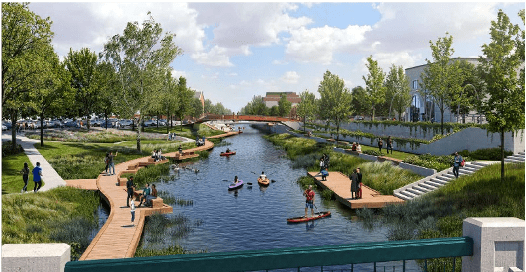
The Unified Plan identified a desire to repurpose and transform this section of the river into an active riverwalk/pedestrian zone – an interesting and unique place for people to gather, interact with each other, and also engage with the river, surrounding businesses and adjacent public spaces, including the Farmers Market and Clinch Park (see the Unified Plan concept sketches below).
Unified Plan Concept for the 100 and 200 Block River Corridor
On the heels of the Unified Plan, in 2022 the DDA hired INFORM Studio and their team of urban designers, placemaking and mobility experts, architects, engineers and community engagement specialists to develop a conceptual design for a downtown riverwalk along the Boardman/Ottawa River between Union Street and Park Street.
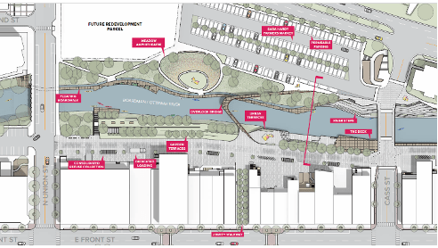
In November of 2022, following an 11-month planning and design process that included extensive public engagement, the DDA Board approved a conceptual design for the downtown riverwalk. The conceptual design addressed several components, including mobility, public infrastructure (lighting, furniture, public restrooms, dumpsters, etc.), ecology, the built environment and water access, programming and placemaking recreation and activities, and maintenance. The conceptual design also included construction estimates for the overall project.
Conceptual Riverwalk Design between Union and Cass Streets (INFORM)
With the conceptual design in place, in 2025, the DDA worked with INFORM Studio again to develop a Schematic Design for a narrow focus of the proposed Riverwalk Project – Phase One includes the J-Smith Walkway, new pedestrian amenities through the alley and parking lot, and a new pedestrian bridge over to improvements on the north side of the river (including the planned Farmers Market Pavillion). As part of this modified scope, we are also looking to incorporate new stormwater management infrastructure and habitat restoration infrastructure. The Schematic Design was approved by the DDA Board at their January 2026 meeting.